Thursday, 22 January 2009

Big Lagoon

Tuesday 20th January 2009
"It's a stretch of sea water separated from the sea by a low sandbank or coral reef", I said to my dog Amy as we walked north of Agate Beach towards Big Lagoon. We would be having close encounters with four lagoons this week so I thought it advisable to explain the word to Amy as she often had difficulty with complex concepts such as "sit", "stay", and "stop chasing that seagull". I might as well have saved my breath as she took little notice and continued to pull me along the sands even though I protested that our chosen route took us along the east side of Big Lagoon up the great Redwood Highway. Amy had different ideas, she wanted us to walk up the narrow strip of sand and shingle that separated the wild Pacific from the still Lagoon waters. "Hang on, Amy, I'm not sure it is safe", I said as she dragged me north. "Perhaps you can't get through", I tried. She pressed on. "Perhaps it's private property", I declared. She quickened her pace. "Perhaps dogs aren't allowed", said I throwing it my trump card. She trumped my trump so we kept heading up the sand spit.

According to the guidebooks, gold-seekers swarmed into this area in 1849 when discoveries were made along the Klamath and Trinity rivers. Prospectors attempted to mine the sand spits, but managed to extract very little gold despite considerable effort. It was only when we were a mile or two up the spit that I got to the paragraph which warned that particular care was needed as several times each winter the lagoon barrier is breached by waves. From there onwards I kept my eyes neurotically on the waves to our left, imagining with each incoming wave that the narrow strip of sand was getting narrower. Amy seemed relaxed about it and happily ran around searching for gold. By the time we passed the half-way mark it was me pressing ahead and Amy being dragged along in my wake. When we eventually got to the northern end of the sand spit she stopped and gave my one of her looks. It was as if to say, "what's all the fuss about, it was a lagoon, separated from the sea by a low sandbank .... ".

LINKS

Monday, 19 January 2009

Week 45 : Patrick's Point To Orick

You will recall that Amy and I are speeding north, heading for the County Line having illegally allowed a dog (Amy) to sleep in a hotel room which did not welcome pets. Although we won't quite make the County Line in the week ahead, our route will take us through Humboldt Lagoons State Park. By next weekend we should arrive at the town of Orick .... unless the pet police catch us first.

Patrick's Point State Park

"If there is a dog you particularly fancy, you could get married", I said to Amy as we walked from the Patrick's Point Inn where we had spent the previous night along the path to Wedding Rock. I was wasting my breath as Amy rarely answers me. Also she was sulking as Patricks Point Inn had displayed one of those annoying "Sorry, No Pets Please" signs hanging in its window, so Amy had to be smuggled into my room surreptitiously. Hopefully she left a good doggy-smell to permeate the room, and equally hopefully we will be across the County Line before this is discovered.

Wedding Rock really is used for weddings and one can only admire the determination of couples - not to mention the sure-footed courage of their bridesmaids, ushers, sisters, brothers and maiden aunts - who traverse the rocky staircase up to the rock. This spot has been popular for weddings ever since the original caretaker of Patrick's Point State Park was married there in the 1930s. The State Park website says "it's a uniquely special place to start the journey through life together--a rock-solid foundation for wedded bliss". There were no weddings taking place on the day we visited, and Amy hadn't come up with a suitable mate, and therefore we took the path back to Agate Beach to see if we could pick up a fortune.

We found nothing so we contented ourselves with sitting in the shade of a giant Redwood tree and planning out our walk for the coming week.

LINKS

Thursday, 15 January 2009

And So To Trinidad


Thursday 15th January 2009
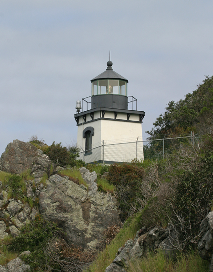
And so to Trinidad ... In case that sounds a bit exotic even for this pair of virtual travellers let me immediately point out that today we arrived at Trinidad in Humboldt Country and not Trinidad in the Caribbean. Nothing wrong with Trinidad Ca, mind you: this little seaside town doesn't need to stand in awe of anyone. Actually, it's not a town but a city, and with a population of just over 300, it is California's smallest incorporated city. Small it may be, but it has two lighthouses, ten public beaches and the gateway to a National Monument within its city boundary. Add to this the fact that many claim that it is the oldest incorporated city in California and that it used to be the County seat of the long-gone Klamath County, and you can see that tiny Trinidad punches well above its weight.

Let's start with those two lighthouses : there is nothing much to choose between them because they both look very similar. Trinidad Head juts out into the Pacific Ocean and its phalanx of sharp rocks and craggy bluffs coupled with the areas natural inclination towards sea fogs leads to a natural hazard to shipping. From the 1850s onwards Trinidad became an important harbour for both the gold prospecting valleys of Klamath County and, later, the lumber industry, and therefore a lighthouse was an urgent requirement.  The Lighthouse Friends website takes up the story :

"In 1866, forty-two acres were purchased for a light station on the southern portion of the headland, but work on the project did not begin until the spring of 1871. First, a road was carved into the eastern side of the head, and then work began on the Trinidad Head Lighthouse, which would stand at the top of a 175-foot cliff. Given the loftiness of its perch, a squat brick tower was deemed adequate. The tower and associated keeper's dwelling, located roughly fifty yards from the tower, were finished over the course of the summer and fall, and on December 1, 1871, Keeper Jeremiah Kiler activated the revolving fourth-order Fresnel lens for the first time".

An important part of the installation was a fog bell which was set into the cliffs some fifty feet below the height of the light. The bell was struck using a clockwork mechanism which had to be wound up by the lighthouse keepers every two hours, an exhausting business.  Electricity didn't come to the lighthouse until the 1940s, but then the old Fresnel lens was removed along with the metal fog bell. It was then that the citizens of Trinidad clubbed together and built a second lighthouse - nearer the centre of the city - to house the relics. This is the Trinidad Memorial Lighthouse shown in the picture above.  

As Amy and I stood on top of Trinidad Head we looked out on what is the magnificent California Coastal National Monument for which Trinidad is one of the five "gateways". In all the monument covers 1,100 miles of coastline and some 20,000 small islands, rocks, exposed reefs and pinnacles. Established in 2000, the primary objective of the monument is to "protect the important geologic features and the unique habitat they provide for both terrestrial and marine plants and animals found within its boundaries". This is why, I said to Amy who was getting distracted by certain movements along the cliff edge, you can't chase the birds.

We walked back into Trinidad, it really is a super little town (I can't get my head around the idea of it being a city). Within a few weeks, Amy and I would be leaving California for the state of Oregon. This little town with its rocks and its lighthouses would form just as powerful a memory of the state as would the mighty cities of Los Angeles and San Francisco.

LINKS

Another Moonstone Beach


Tuesday 13th January 2009
"I'm sure we've been here before", I said to Amy as we headed off Highway 101 down Moonstone Beach Road. The sound of the traffic eventually gave way to the sound of the surf and in front of us we saw a wonderful collection of surf-piercing rocks and near-forgotten rock pools. Amy dropped  her head to one side which made for a quizzical look : she tends to do this whenever I do something or say something she doesn't understand. "Moonstone Beach, Moonstone Beach" I repeat as I flip back through our collected travel diaries. "Ah, here we are, it's just south of San Simeon and we visited it months and months ago". Amy dropped her head a few more degrees from the horizontal plane, which tends to mean "fool" : and in this particular case "it's another Moonstone Beach you old fool". 

We walked on the beach and caught site of Camel Rock in the distance. Named because of its two prominent humps, the rock is a local landmark and a popular gathering point for surfers. The beach is a fine sandy beach and, unlike its Southern California namesake, is relatively unlittered with pebbles or driftwood. After a while we left the beach and wandered up to the Moonstone Grill where we surveyed the menu with much thought. "California Red Abalone medallions lighted coated in almonds and cracker crumbs and served over angel hair pasta in a sauce of chablis, butter capers and fresh herbs" is one of the house specialities but I stuck to good old steak and fries. Amy decided to be adventurous so I ordered her the sauteed duck breast. "Very tasty", I said as I washed down the last of my rib-eye steak with a glass of local wine. Amy gulped down the last of her duck and dropped her head a few degrees from the horizontal plane. Undoubtedly this meant "very tasty"

LINKS

Tuesday, 13 January 2009

Week 44 : McKinleyville to Patrick's Point

Amy and I plan to keep to the coast this week, as we make our way north from McKinleyville to Patrick's Point. The beaches should be pristine, the coves should be craggy and every time we look inland we should see the ever-present tall redwood trees. Midweek we should pass through the city of Trinidad and by the end of the week we should arrive at Patrick's Point State Park.

Sunday, 11 January 2009

McKinleyville Totem Pole

Sunday 11th January 2009
For the last two days we have been walking north up Highway 101 towards our goal of McKinleyville. Someone once asked Amy how we choose our weekly goals which was rather stupid as she is a dog and doesn't speak. If they had asked me I would have said that they need to be about the right weekly walking distance from our starting point and, if possible, there should be something vaguely interesting about them. So what is vaguely interesting about McKinleyville? It has the world's largest single totem pole in the car park just outside Safeway's, that's what.

If you read the notice at the bottom of the pole you will discover that it is 160 feet high, weighing 57,000 lbs and 500 year old. This all sound quite impressive until you discover that it is not alone in claiming to be the world's largest totem pole - there are rivals in both Oklahoma and British Columbia - and it is 500 years old in the same way that my house - which is stone built - is 37 million years old. The redwood tree itself is 500 year old but it wasn't made into a totem pole until 1962. In totem pole terms it is a "celebration pole" and it celebrates the opening of McKinleyville Shopping Centre.  For Amy and I it celebrated the end of another week's walking and for Amy in particular, it posed a challenge of monumental proportions. Now what would any self-respecting dog do to a 160 foot high wooden pole?   

LINKS: