
Amy and her travelling companion are on holiday. They will return at the beginning of September.

 All you can do is to make a drunken bee-line to one or two places you particularly want to see and leave the rest to the next time you virtually pass by. Thus Amy and I called in for a pint of Guinness at Kate O’Briens on Howard and 2nd , bought a hot dog at The Dog Out on Market Street and headed up towards Haight Ashbury. Haight Ashbury, I explained to Amy as I tucked a flower in her fur, is resonant of youth, peace, love and music.
 During the 1960s, young people from all over the world flocked to San Francisco – and in particular to the streets around Haight Street and Ashbury Street – to “turn on, tune in, and drop out”. As Amy and I walked the streets, which are now more of a tourist destination than a beacon of the alternative culture, I couldn’t help wondering why they came here. The district is looking a bit tired and shabby. As I caught a reflection of Amy and I in a shop window I decided it was a suitable place for us. We were looking a bit tired and shabby as well.
 The herd of buffalo are to be found in the buffalo paddock which was established at the end of the nineteenth century with the aim of protecting the largest of all the North American land animals which, by then, were on the verge of extinction. The first herd to take up residence all died of TB whilst the second – acquired from the legendary Buffalo Bill – had “temperamental problems” (it took 80 men to recapture one escaped bull). Amy and I gazed over the fence at the huge beasts. I was trying to imagine a time when they roamed the great plains in their hundreds of thousand. Amy was trying to imagine them in bite-size pieces.The trouble with my travelling companion – as I have suggested a number of times over the last six months – is that she has no soul.
 It was a nice thought to bear in mind as we headed for the east sidewalk of the iconic Golden Gate Bridge, where, as well as pedestrians, dogs are allowed to cross over to Marin County. It was such a rare event for dogs to be allowed to do anything within a national park or monument, that Amy and I walked to the middle of the bridge. Then we headed back for the city and the airport. The first stage of our journey was now over. A short holiday had been promised.
 However we had only just scraped the surface. We had covered just one-tenth of the total distance from Los Angeles to New York (via Seattle). We needed to be in this in the long-term.
 Amy and I start the week walking north along the final few yards of Skyline Boulevard, heading for the city of San Francisco. Skyline Boulevard is quite some road, which cuts through the backcountry of Silicon Valley and runs along the ridgeline of the Santa Cruz Mountains. For a while it is like being back in the country again : to the right are the city streets and houses I have become over-familiar with but to the left a mountainous green wedge digs into the fleshy under-belly of San Francisco. I almost wish I had walked the length of Skyline, creeping into the metropolis by stealth rather than taking the digital route via Silicon Valley. Pointing south, I tell Amy that just a few miles up the road is the famous Alice’s Restaurant. Her tail wags from side to side. She likes restaurants. But we head north. “It’s the streets of San Francisco for you girl”, I say. The phrase rolls easily from my tongue.
 But there again it would do. “The Streets of San Francisco” are part of my heritage – I spent hours watching the TV series thirty-odd years ago. And when I wasn’t keeping up to date with the events in the lives of Detectives Stone and Keller on television I was at the cinema feeling slightly travel sick as Steve McQueen (aka Lt. Frank Bullitt) crashed and screeched up and down the same streets. San Francisco, like Los Angeles I suppose, is a “World Heritage Site of the Imagination”. The United Nations hasn’t started designating such places yet, but when they do they could start with San Francisco.
 San Bruno mountain is a shock. You don’t expect it. Right in the middle of the urban sprawl that is San Francisco there is this dirty, great big mountain. Amy and I were halted in our tracks. We looked at each other but didn’t need to speak. We both knew what we were going to do. We were going to climb it.
 I managed just one – a starling (although I gave it its official name of Sturnus vulgaris in order to impress Amy) whilst she also claimed a score of one – a chicken. I was tempted to discount her score on the basis that (1) a chicken was not on the list of 91 birds, and (2) it had been fried and battered and left by someone at the side of the path, but I thought that was perhaps uncharitable and therefore I said nothing. Getting bored with that game, we moved onto another : how many regulations of the San Bruno State Park could we break at the same time. We did a lot better on this game. The very fact that Amy was on the mountain was in breach of one regulation. I picked a passing daisy and claimed a point. Amy let loose a large bark and reclaimed the lead. I pulled a small bottle of Lagavoulin Single Malt out of my back-pack and picked up another point. It was only when Amy squatted down amongst the scrub and brush proclaiming “beat that” that I called an end to the game.
 When we eventually got down the other side of the mountain I tried to explain to Amy why Cow Palace was not the home of some bovine deity. “It’s a convention and exhibition centre”, I explained. “The home of events such as the Grand National Rodeo, Horse and Stock Show, the San Francisco Flower and Garden Show, circuses and music concerts”. “It’s where the annual Golden Gate Kennel Club Dog Show is held”, I added, hoping this would impress her. She was a bit dismissive, saying something about Size 0 models with fake hairpieces.
 We were back in the urban jungle and now we entered San Francisco proper : we crossed the County Line. San Francisco is both a city and a County. As far as I could make out from reading the SFGov website, the City and County government structures are totally integrated : there is one mayor, one set of departments, one Police Department, that kind of thing. As a city it is the fourteenth-most populous in the United States, and the second most densely populated major city in the country. As a County it must be the smallest in California and one of the smallest in the country. It is a new city which hardly existed at all before the 1840s gold rush. More than most cities, its history is dominated by one event : the earthquake and fire of 1906.
 If you want to get a good overview of the great earthquake and the subsequent fire you can go to the excellent on-line Exhibition hosted by the Bancroft Library. To get an idea of the scale of the devastation, make sure you have a look at the amazing panoramic view of the City taken from Nob Hill shortly after the fire. The fact that the city has been able to rebuild itself, the fact that it retains its thrusting optimism in the face of the constant threat of renewed destruction : these are all part of the attraction of the city. The City By The Bay is a good place to visit.
 Amy and I made our way north through the old docklands area. Candlestick Point, Hunters Point, India Basin and Lash Lighter Basin : we drank in the evocative names. Many of them are old industrial areas which are rapidly being re-invented as the most desirable places to live. “Contemporary living hits a high watermark at Candlestick Point – The Cove”, trills one website, “the latest development that’s fast becoming one of the City’s most desirable addresses”. “This exclusive gated community is located on a secluded cove overlooking San Francisco Bay”. Amy and I pushed our noses through the bars of the gate. Very nice … but not for us.
 We finished our week in the Mission Bay area of downtown San Francisco. Again it is an old industrial area which is undergoing rapid regeneration, in this case driven by the new Mission Bay Campus of the University of California, San Francisco (UCSF). The view looking north from the new Genentech building gives an impression of how close Amy and I were to the end of the first part of our journey. In just a few days time we would reach the Golden Gate Bridge and reward ourselves with a short (non-virtual) holiday.

 As we walked along the streets and paths of Foster City, Amy remarked on the relatively few dogs she had seen. I had to point out to her that there were strict local ordinances on the maximum number of dogs or cats that could be kept per household. She said something like "fascist state", but it could have been "lick-slurp" : there were a lot of noisy speedboats chugging along the waterways.
 Leaving Foster City behind we made our way to Coyote Point which sticks out into San Francisco Bay like a septic pimple. Here we found Coyote Point Museum, a splendid educational facility dedicated to providing "engaging, educational experiences for our diverse, multi-generational Bay Area community through wildlife, gardens, exhibitions, and programs that relate to the global environment". Amy was particularly attracted by the posters encouraging visitors to adopt an animal. She seemed very keen to adopt a domestic rabbit and I became somewhat suspicious of her motives. Eventually, I offered to fund the adoption of a Banana Slug, but she seemed to have lost interest by then.
 If you sit on the breakwater that forms the northern edge of the marina you get a spectacular view of San Francisco International Airport, the main runway of which is about a couple of miles away. San Francisco International Airport (SFO to its friends and baggage tags) is the major international airport of northern California. It is the fourteenth largest airport in the USA and the twenty-third largest in the world. Until 1927, what is now a major international air terminal was a cow pasture. During the latter half of the twentieth century the airport experienced rapid growth and it is currently attempting to win support for a major runway extension. The problem is, that the only place to extend the runway to is further out into the Bay. One of the most spectacular building is the new International Terminal which was opened in 2000. As I told Amy as we walked by, it is the largest international terminal in North America and the largest building in the world built on base isolators (special thingies used in the construction process to protect against earthquake damage). Amy yawned. We said goodbye to SFO for the time being, but we would be back here again in a couple of weeks on our virtual way home for a short holiday.
 Later we passed through the City of Burlingame, which is getting ready to celebrate its centenary. And what a delightful little eccentric city it is. The city website has a section entitled "Extraordinary Burlingamers". These include Steven Backman who recently built a 13 foot replica of the Golden Gate Bridge using nothing other than 30,000 toothpicks. Also included is inventor, Robert Barrows, who recently filed a patent application for “Talking Tombstone,” a hollow headstone that allows the deceased to speak via a recorded message that is seen and heard when a touchscreen is activated. And let us not forget Steve Hurwitz who currently holds the world record for swimming from Alcatraz Island to the mainland (just a few weeks ago he swam back and forth to the island for the 500th time in order to commemorate the 45th anniversary of the infamous last escape from the prison island). As I said to Amy and we walked by the Steelhead Brewing Company, this is the kind of place I feel at home in, the kind of place I could settle down in. Amy was not impressed. She pulled on the lead and we headed out of town.


 I made a mistake the other week when I referred to San Francisco as being the largest city in California. It isn’t (that honour belongs to Los Angeles). It’s just that it feels like it. As you pound the streets of the Bay area, it is impossible to know where one city starts and another ends. During the last week, Amy – my wheaten terrier – and I have walked through the cities of Palo Alto, Menlo Park, Redwood City, San Carlos and Belmont and we have hardly worked up a sweat. In total we have covered less than 12 miles which is the lowest mileage we have clocked up in a week since we started this journey. The problem is – and I am a bit ashamed to admit this – it is all a little bit tedious. It is not easy to convey what it is like to walk along such unchanging streets and highways, where variety is a different façade on a MacDonalds restaurant. Not easy, but it can be done.
 We did manage to feel some grass beneath our feet. To assuage the tedium we planned our daily walks so that they would always start and finish in a park. This wasn’t particularly difficult, the urban Bay area is dotted with neighbourhood parks. But with just a few exceptions these are less than inspiring – patches of green where you can throw a football around or jog a few laps of a track. They did little more than provide a series of punctuation marks for our week’s journey : Nealon Park, Holbrook Palmer Park, Fleishman’s Park, Hawes Park, Mezes Park, E R Burton Park, and finally Twin Pines Park. Amy and I discovered that if you repeat all of the names, like a mantra, it sends you to sleep. Just try it. Nealon Park, Fleishman’s Park, Hawes Park ……
 We must have been asleep when we walked over the County Line on our first day out of Palo Alto. In blissful sleep we said goodbye to Santa Clara and hello to San Mateo. The County seal features a tree, some flowers, a few mountains, and a bit of sea. There is a bit of space left on the design so you can draw your own burger bar, freeway, and motel on it. If you look carefully you will see that someone has made a start by pencilling-in an aeroplane taking-off from the pine tree at an alarming angle.
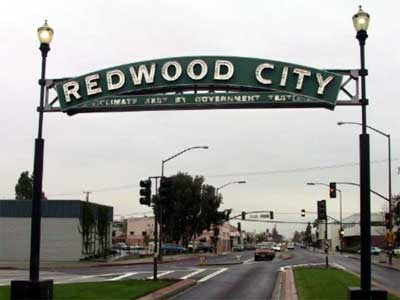 At some point during the week we passed through Redwood City. The only thing I can recall is a large sign which proclaims the name of the city and the its’ slogan : “Climate Best by Government Test”. Intrigued, I checked out the scientific basis of this claim. It would appear that in the early years of the twentieth century, a joint survey was undertaken by the American and German governments to identify the place with the best climate in the world. Why they should want to do this is anyone’s guess – perhaps they were working out where to invade next – but, it appears that Redwood City, California shared joint first place along with the Canary Islands and North Africa! As a USP (unique selling point) the claim seems somewhat tenuous and Amy intimated as much. “What else is there to say about the place?”, I replied.
 The following day, either the Canary Islands or Tangiers must have pulled ahead in the tie-breaker for it started to rain. For the first time since the start of our trans-continental trek I was seriously tempted to catch a bus. It was Amy who pointed out the logical flaw in this illogical plan : neither of us had seen a bus for the last five or six weeks. And so we pressed on.